Version 21.00 Released
Version 21.00 Newsletter
In this issue:
Version 21.00 Released
File Compatibility
Other Resources: Technotes and Videos
Classes and Events - Save the Date for ATUG 2026!
Current Versions
What is the Insider Release and How Do I Get It?
Version 21.00 Released
Power Line Systemsis excited to announce that we have released Version 21.00. This General Release is jam packed with features and improvements.
Automatic Model Builder (AMBER)
The Automatic Model Builder (AMBER) was introduced in Version 20 that enables users to take classified LiDAR data of their existing transmission and distribution lines to get a head start with building a model with an alignment, its Method 1 structures, and wires. In Version 21 we have continued to enhance AMBER’s accuracy by expanding from using single phase sets to multi-phase sets with their own wire cable file, set numbers, and attachment classifications. These improvements greatly reduce the amount of time to model a line from existing LiDAR data. Our YouTube video walks you through the entire process.
With AMBER, create a model based on classified LiDAR with Method 1 structures and sections strung
Calculate Section Relative Sag
Calculating a section’s horizontal tension relative to another section’s sag is now made easy with Calculate Section Relative Sag found in the Sections/Modify dialog and in the Sections/Table... in PLS-CADD. Now you can select a reference section, weather case and a percentage of mid span sag of the reference section and PLS-CADD will calculate the section tension for you. In the example image below, the shield wire in Section 4 can be sagged to 80% of phase conductor in Section 10’s mid span sag for the 60 Deg F weather case.
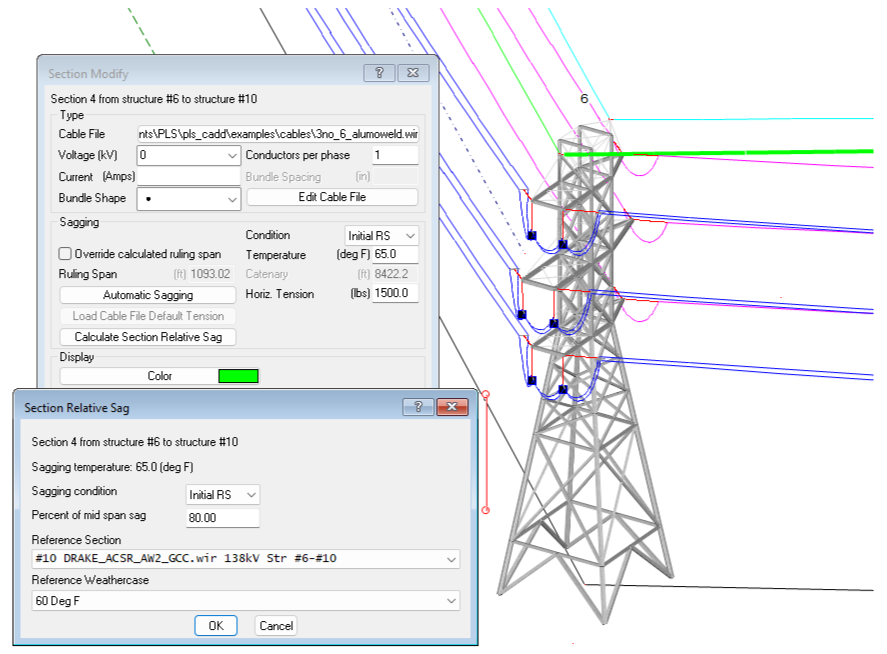
Calculate section tension relative to a percentage of another section’s mid span sag
PLS-GRID’s Web Feature Services (WFS) Integration with GIS Tools
PLS-GRID now supports Web Feature Services (WFS) which enables integration with Geographic Information Systems (GIS) providing structure and span information. Assets managed in a GIS application can be seamlessly updated as soon as the PLS-CADD model is checked into PLS-GRID’s Project Manager. All PLS-CADD project metadata as well as each structure and associated span data can be queried and managed in a GIS application. Watch our YouTube video to see it in action.
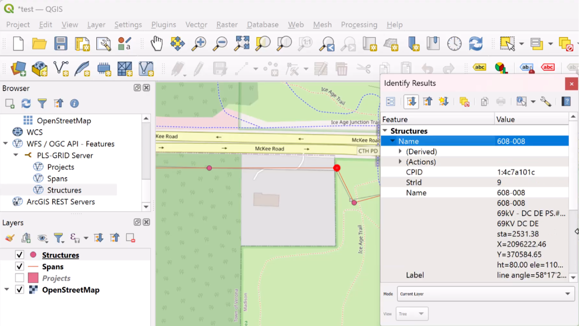
Viewing a PLS-CADD project that was uploaded to PLS-GRID and now available in a GIS application
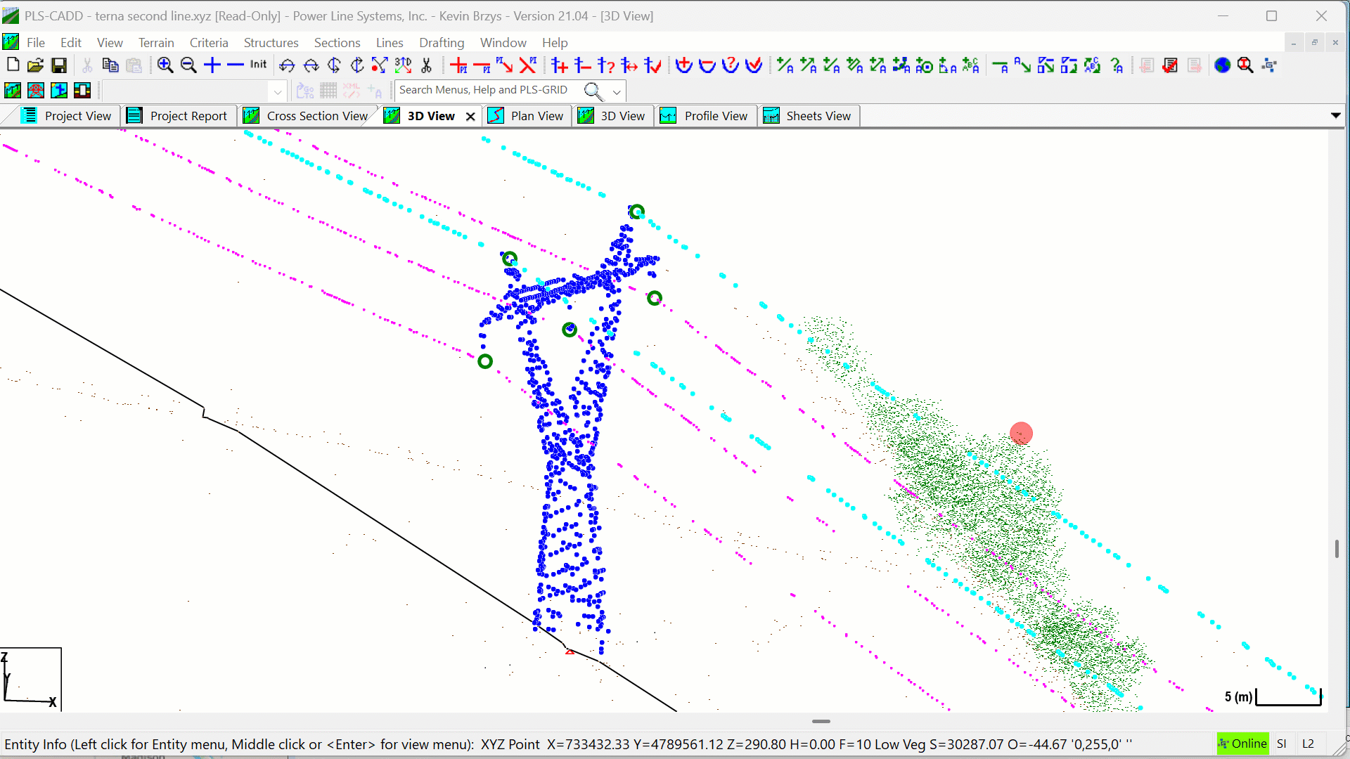
Multiple Surface TINs
PLS-CADD’s TIN Manager continues to evolve in Version 21 with support for multiple surface TINs. Now users can create any number of surface TINs and display them simultaneously. Each surface TIN is created from one or more survey point feature codes and can also have its own clearance requirement feature code when checking clearances between wires and the surface TIN.
Example with standard Ground TIN, vegetation/tree Surface TIN (in green), and Building Surface TIN (with aerial imagery overlaid)
Section Groups
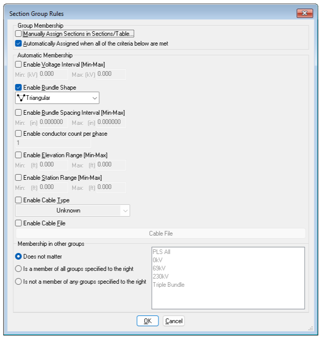
Section Groups can be used to create groups of wires for automatic sagging and cable reporting. Similar to Structure Groups, users can manually add sections to a group or have it automatically assigned based on different criteria such as voltage range, bundle shape/spacing, number of conductors per phase, elevation or station range, and finally cable type or specific cable file. Once the Section Groups have been defined and assigned, they can be utilized with “Criteria/Automatic Sagging…” and “Criteria/Cable Tensions…”.

The power of Section Groups can be seen by reducing the number of criteria conditions necessary, thus making your model more efficient to manage. You can learn more about Section Groups in our YouTube video.
Version 21.00 continues our long tradition of meeting client requests for additional features and functionality while also supporting the latest industry standards. Some notable features are highlighted below:
All Programs
Insulator Improvements:
Now support insulator set numbers up to 999 and up to 100 separate insulator sets per structure.
Now allow lambda insulators to have a non-zero compression capacity.
PLS-CADD: Allow changing of the separator cable length between lambda or double suspension insulators.
PLS-POLE/TOWER: Improved the double pin insulator cantilever load/usage calculation.
PLS-POLE/TOWER: No longer constrain the rotation of double pin insulator tip joints.
Exporting Improvements:
Exported DXF files now support solid fill hatches.
"Export" added to the context menu in report windows to provide the available export options for all schemas in the report in one dialog.
Added the JSON file format to schema report "Export" options as an alternative to XML.
PLS-CADD: "File/Export/LAS/LAZ..." which exports project survey data to a LAS or LAZ file with support for color and feature code to ASPRS classification mapping.
PLS-POLE/TOWER: Added an option to "File/Export/DXF..." to use the model coordinate system instead of positioning the model to lie in the XY plane.
Added a new annotation view type of 'Sheet Range' to "Drafting/Lines and Annotation/Table Edit..." which displays annotations on a user selected subset of sheet pages.
Added 'Decomposed Assemblies Parts Table' option to Bill of Material reports which provides part counts per assembly.
Added a 'Hilite Material in Model' (PLS-POLE/TOWER) / ‘Hilite Material in Line’ (PLS-CADD) button to the 'Parts Editor' and 'Assemblies Editor' dialogs which highlights the rows in the table of parts/assemblies that are used in the model/line.
PLS-CADD
Added support for Section Groups to "Criteria/Automatic Sagging...", "Drafting/Structure and Section Labeling/Sheet Profile View...", and "Criteria/Cable Tensions..."
Line Merge is used to merge structures and sections from two different Line Edits into a single line. We made several improvements to this feature:
‘Graphical Merge’ is a new option to “Lines/Merge…” for quickly highlighting structures and sections from areas selected on two different line edits and merging into a new line edit.
Added a 'Structure Model Differences' button to 'Merge Structures' dialog when merging line models, which uses PLS-POLE or TOWER to generate a full differences report for the selected structures.
In "Sections/Modify" & "Sections/Table..." added a 'Sag Relative to Section' command to sag a section as a percentage relative to another section at a given condition and weather case.
Added support for weather case clearance overrides to "Terrain/Feature Code Data/Edit..." using the 'Override Clearances' column. These overrides affect results in 'Survey Point Clearances', 'Danger Tree', and 'Clearance to TIN' reports.
TIN Improvements:
Now can have multiple surface TINs visible at the same time.
Added the ability to assign unique Feature Codes for clearances to each Surface TIN in "Terrain/Feature Code Data/Feature Code for Ground Clearance and Interpolated TIN Points"
Several updates to "Terrain/TIN/TIN Manager" to make it look and behave more like the 'Attachment Manager' and 'Reference Manager' dialogs.
Electrical Improvements:
Added options to "Sections/Electric/Audible Noise Calculator..." to build L5 and L50 contour line TINs.
'Fixed Angle' option added to "Sections/Electric/Lightning Protection Calculator..." as an alternative to the rolling sphere method.
In "Sections/Electric/3D EMF Calculator..." added the 'Survey Point Report' option which lists EMF magnitude and survey point comments at specified feature codes.
In "View/Entity Info Snap Settings..." added '3D Electric Field TIN' and '3D Magnetic Field TIN' options to view the field strengths at specific vertices in the status bar.
In "Sections/Stringing Chart/Multiple Sections..." the Section Stringing Charts now have schema so they can be viewed as tables, added as inset views to sheets, and exported to XML or JSON.
PLS-POLE / TOWER
Added a new annotation view type of 'Sheet Range' to "Drafting/Lines and Annotation/Table Edit..." which displays annotations on a user selected subset of sheet pages.
Use the 'Digits of precision to use for Dimension Annotation' setting in "File/Preferences..." with both "Drafting/Annotation (Program-Generated)/Auto Add Dimension Lines" and "Drafting/Annotation (User-Input)/Add/Dimension Snap..."
Increased the maximum number of members in the model to 100,000 from the previous limit of 36,000.
PLS-POLE
Framing Improvements
"Components/Framing/Add Rectangular Extents..." creates a frame set from graphical rectangular selection in a PLS-POLE model.
"Geometry/Framing/Explode Selected" to only explode frame sets within a graphical rectangular selection.
Framing is now included in Library File Protection so pole models can restore any missing frame sets automatically.
Added the option to specify the frame set distance relative to ground.
Expanded 'Notes' and 'Keywords' character limits from 39 to 255 in the Framing Library.
Added a new 'AutoTxTy' connection type to "Geometry/Cross Arms..." to model vertical crossarm elements on poles. Any cross arm pointing downward with two or more attachment points and at least one of its connections using the new AutoTxTy connection type will act as a connection point on the crossarm that prevents lateral displacement of the corresponding attachment points. This is used to model pole bracing members that extend below ground that can be used to enforce existing pole strength near ground line.
For "Components/Concrete Pole...", added a new experimental option of 'Calculate' to the 'Strength Definition' column which will compute a moment capacity curve based on information entered in the 'Capacity Analysis Options' column.
TOWER
Member split processes the 'Auto Adjust' unbraced lengths option by simplifying the calculation to factoring the original RL* by the ratio of old length to new length.
Added buttons for 'Edit Angle Groups', 'Edit Angle Properties', and 'Edit Bolt Properties' to "Geometry/Members/Table Edit" and added a button for 'Edit Angle Properties' to "Geometry/Groups/Table Edit".
PLS-GRID
Added support for Web Feature Service (WFS) so external tools can query a PLS-GRID server for information on projects, structures, and spans which is useful for linking to GIS platforms.
For "File/PLS-GRID/Grid Analytics...", added the option 'Select LAS/LAZ survey data files to use for reports' which overrides the selected projects' survey data with specified LAS/LAZ data before generating reports.
Right of way information can now be uploaded from "Terrain/Alignment/Display Options for P.I., Alignment, Right of Way..." to the PLS-GRID server and display that information in the Grid View window.
Projects added or checked in to a PLS-GRID server now include material information which can be viewed from the PLS-GRID map view.
Add support to query project, structure, and span material from GRID Map View.
Add support to create a new PLS-CADD/LITE project using a PLS-CADD template from PLS-GRID.
Added a new command, "File/PLS-GRID/Get Standard Projects", which pulls down all template projects to the 'PLS-GRID Standard Templates' subdirectory in the user's workspace.
Added "Delete From Workspace" context menu command in Project Manager Discovery which removes files from the project's workspace subdirectory after verifying the file is archived on the PLS-GRID server.
Improved the handling of directly modifying structures that belong to a PLS-CADD project that is part of PLS-GRID, so you can see what project it belongs to and have the option to check out that project.
Added disconnected or offline mode for Web Client Map View including cached reference files and map info.
Improved the batch update functionality which updates the same file for multiple projects to include a more descriptive revision description which clearly identifies all affected files.
Added support for OIDC based SSO.
Add support for authenticating desktop users via SSO and added ability to configure a separate SSO Identity Provider for desktop client authentication (PLS-CADD/PLS-POLE/TOWER).
Updated coordinate system project library to support GeoTIFF grid/projection files and will now automatically download missing/required GeoTIFF grid/projection files.
What about File Compatibility?
PLS applications will always save files in the most compatible format based on the features used by the model. If you are not using new features that require file format changes, the software will automatically save to an older file version that will be backwards compatible with versions 19.01 and later.
Less than a dozen features require file format changes and you will be notified which ones that do so you can decide if you want to turn off that new feature to ensure it can be opened by an older version, putting you in full control of file compatibility.
For more details on File Compatibility, please see our white paper.
Other Resources: Technotes / Videos
Our solutions engineers have been busy expanding our library of technical notes and videos. We hope that this supplemental feature documentation makes your use of the software more pleasant and productive. Please let us know if you have a topic that you think would benefit from a technical note or video. Here are our latest efforts:
Technical Notes:
Videos:
Classes and Events
Save the date for ATUG 2026
Our next Advanced Training and User Group (ATUG) meeting is right around the corner, June 9th - 11th, 2026. The ATUG meeting is a great way for users to come together and learn how to get the most out of your PLS software.
More information to follow at the start of next year. If you would like to present on a topic please submit your presentation idea to support@powerlinesystems.com. We look forward to hosting here in Madison, WI !!
The current schedule of available classes is shown below. You can sign up for our PLS Training Newsletter (separate from this mailing list) to be notified as soon as there are new class offerings.
University of Wisconsin Classes
Introductory – Design of Overhead Transmission and Distribution Lines Using PLS-CADD (includes 32 PDHs)
December 8th-12th 2025 - Orlando, FL
This course will teach the attendee how to use the core functionality of PLS-CADD and PLS-POLE on a transmission or distribution project from start to finish, including importing survey data, criteria development, structure design, conductor sagging, Plan & Profile drawing development and material management.
Current Versions
The current General Release versions of our software are listed below. These versions support the 64-bit editions of Windows 10 and 11.

We strongly encourage you to upgrade to the current General Release versions of all the applications you own. To do so please use the Help/Download Upgrade command built into your PLS software. This would also be a good time to use the Help/Check for Updated Manual command to obtain the latest edition of the manuals. If your licenses have expired, then please email sales@powerlinesystems.com for a renewal quotation.
Our current Insider Release version for PLS-CADD, PLS-POLE, and TOWER are 21.07. Our Insider Releases are incremental versions between our General Release versions with the latest features and improvements. If you are not currently receiving our Insider Release updates and would like to have access to them, please send an email to support@powerlinesystems.com with your request.
As always, we welcome your suggestions and comments on our software. Please send them to support@powerlinesystems.com.
If you are not receiving these newsletters directly and would like to do so, please register at PLS Mailing List
